
Inca's Way in the Escoipe's Gorge
By Christian Vitry
Translation by Luis Alberto Passarell
One
of the so many long walks or tourist circuits of Trekking practiced
i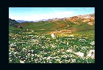 n
the Province of Salta is the passage by the Serranías del
Candado, that starts off in southern sense from the colorfull
Encantado Valley located in the Los Cardones's National Park - and it
descends by a noticeable footpath crossing narrow tubes formed by
walls from more than 100 meters from vertical rock. This footpath
arrives until " El Maray ", place located on the foot of La
Cuesta del Obispo in Escoipe's Gorge being able to descry it from the
vehicle when it is journeyed by the provincial route N º 33 that
leads to Cachi. Recent investigations that we made in the zone, put
in evidence that this footpath is in fact one pre-spanish
archaeological way, whose layout over the landscape and used
techniques correspond with the characteristic constructive pattern of
the Incas.
n
the Province of Salta is the passage by the Serranías del
Candado, that starts off in southern sense from the colorfull
Encantado Valley located in the Los Cardones's National Park - and it
descends by a noticeable footpath crossing narrow tubes formed by
walls from more than 100 meters from vertical rock. This footpath
arrives until " El Maray ", place located on the foot of La
Cuesta del Obispo in Escoipe's Gorge being able to descry it from the
vehicle when it is journeyed by the provincial route N º 33 that
leads to Cachi. Recent investigations that we made in the zone, put
in evidence that this footpath is in fact one pre-spanish
archaeological way, whose layout over the landscape and used
techniques correspond with the characteristic constructive pattern of
the Incas.
Many
are the historians and students that mentioned Escoipe's Gorge like
an old communication channel between Lerma's 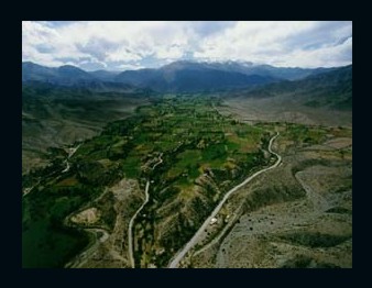 Valley
and Calchaquíes's Valleys, of which we will only mention some
of them. In 1898 the presbyter Julian Toscano in his work "La
Region Calchaquina" made an hipothesis on the itinerary followed
by Diego de Almagro between 1535 and 1536 in its passage to Chile,
affirming that "... by this same gorge, the one of Escoipe, he
moved the thickness of its army, and penetrated in Calchaquí's
Valley, in the direction of Molinos, to enter after in Amaicha's
Gorge " that comfortably facilitates the step to him to
"Antofagasta de la Sierra opening through Tacuil like straighter
way to Hualfin, like more level.
Valley
and Calchaquíes's Valleys, of which we will only mention some
of them. In 1898 the presbyter Julian Toscano in his work "La
Region Calchaquina" made an hipothesis on the itinerary followed
by Diego de Almagro between 1535 and 1536 in its passage to Chile,
affirming that "... by this same gorge, the one of Escoipe, he
moved the thickness of its army, and penetrated in Calchaquí's
Valley, in the direction of Molinos, to enter after in Amaicha's
Gorge " that comfortably facilitates the step to him to
"Antofagasta de la Sierra opening through Tacuil like straighter
way to Hualfin, like more level.
In 1963 Leon Strube Erdman, published through The National University of Córdoba, the work titled "Camino Imperial de los Incas", one of the most important and erudite contributions on the layout and study of incaico's ways. There he mentioned the way of Escoipe when commenting that ".. three great communications towards the West has the vast Valley of Lerma: by the Toro's Gorge, called Perú's Gorge until the last century, comfortable section to the Puna; by the Escoipe's Gorge to superior Calchaqui Valley and by Las Conchas to inferior Calchaquí's valley, all routes by the mountain main channel of the Inca .
The
archaeologist Rodolfo Raffino in "Los Inkas del Kollasuyu"
p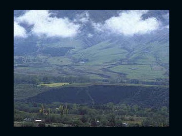 ublished
in 1981 comments that "... This is the old way from the
Spaniards to Peru. The way in Osma would turn towards the West and by
Escoipe's Gorge it would go to the zone of Cachi and there by the
Calchaquí valley towards the South. The stations could
be Agua de los Loros and Tintín to go either Potrero de
Payogasta and Cortaderas or to the Paya-Guitian ". On the other
hand, the historian Teresa Piossek Prebisch(1999) in her book "
Historical Relation of Calchaqui (1696) on the matter the following
thing wrote: "In century XVII, the main one communication
channel between the Interior of the Tucuman and the Alto Perú
was the dirt road that was connecting cities of Interior (...). Two
of them (routes Incas) ended at the city of Salta. They were the
Escoipe Gorge or Cuesta del Obispo and Cafayate's Gorge or Alemanía."
ublished
in 1981 comments that "... This is the old way from the
Spaniards to Peru. The way in Osma would turn towards the West and by
Escoipe's Gorge it would go to the zone of Cachi and there by the
Calchaquí valley towards the South. The stations could
be Agua de los Loros and Tintín to go either Potrero de
Payogasta and Cortaderas or to the Paya-Guitian ". On the other
hand, the historian Teresa Piossek Prebisch(1999) in her book "
Historical Relation of Calchaqui (1696) on the matter the following
thing wrote: "In century XVII, the main one communication
channel between the Interior of the Tucuman and the Alto Perú
was the dirt road that was connecting cities of Interior (...). Two
of them (routes Incas) ended at the city of Salta. They were the
Escoipe Gorge or Cuesta del Obispo and Cafayate's Gorge or Alemanía."
Finally,
the anthropologists Ana Lorandi and Roxana Boixados (1987) publish a
complete and ex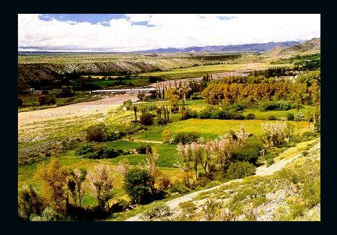 tensive
article titled "Ethnic-history of the Calchaquies Valleys in XVI
and XVII centuries ", where they made a valuable contribution
from the ethnic-history perspective, establishing the relation that
exists between the ethnic group of escoypes with pulares, which they
were entrusted by Hernando de Lerma in the 1582 to Captain Bartholome
Valero. Although the documentation analized for these investigators
does not determine the exact location of pulares and escoypes; a
geographic approach is obtained through the order of earth favor that
presented the Calibay cacique .
tensive
article titled "Ethnic-history of the Calchaquies Valleys in XVI
and XVII centuries ", where they made a valuable contribution
from the ethnic-history perspective, establishing the relation that
exists between the ethnic group of escoypes with pulares, which they
were entrusted by Hernando de Lerma in the 1582 to Captain Bartholome
Valero. Although the documentation analized for these investigators
does not determine the exact location of pulares and escoypes; a
geographic approach is obtained through the order of earth favor that
presented the Calibay cacique .
In the reclamation that next we transcribed, it is clear that Escoipe Gorge was the indigenous and colonial route towards the Alto Perú. Calibay demanded lands pertaining to its ancestors who were in "... the skirts, huaycos and streams that are the Mountain range, hills and slopes that are border to this city (Salta) towards the part and way by where they go to where today are these Indians pulares, that is near the mouth of The Gorge (Escoipe) by where the way of the Pirú goes... "
These brief appointments togheter with the archaeological investigations made about the sections of incaico way, are usefull to confirm the location in the geographic space of the old map course towards the Peru, simultaneously that open a new dimension for the archaeological and historical investigations of the Inca's Horizon, period Hispano-Indigena and Colonial.
The ways of Inca
 The
inca's ways represent a patrimonial legacy of the pre-Columbian
American cultures that were conserved to the present time. The
ethnic-historian Maria Rostworowski (1988) in her book "History
of the Tahuantinsuyu", talks about them saying that: "...
the most importants works that allowed to the terrirorial expansion
and the establishment of the organization of inca's empire was, not
to doubt it, the construction of a vast road's network that implied
bridges, inns and deposits. Few nations could boast in XV century to
have so fantastic road complex as the Tahuantisuyu."
The
inca's ways represent a patrimonial legacy of the pre-Columbian
American cultures that were conserved to the present time. The
ethnic-historian Maria Rostworowski (1988) in her book "History
of the Tahuantinsuyu", talks about them saying that: "...
the most importants works that allowed to the terrirorial expansion
and the establishment of the organization of inca's empire was, not
to doubt it, the construction of a vast road's network that implied
bridges, inns and deposits. Few nations could boast in XV century to
have so fantastic road complex as the Tahuantisuyu."
It is possible to be followed throughout hundreds of kilometers by the varied ambients ones of the Argentine northwest, from the barren landscape of the Puna, passing through the semi-arid Calchaquíes's valleys, following by fertile and tempering Valley of Lerma, to the last stages of the humid SubAndean Mountain ranges, in the limit of the region of the chaqueña's plain.
Ways that oscillate between the 2 and 3 meters wide, whose constructive characteristics vary from the simple cleared cleaning or of the lateral land and milestoned, until paved with stones ways, flagstone, with channels and falsified systems of drainage, like with perrons also sculptured on the mother rock or constructed with stones worked for such aim. Ways exist that ascend by slopes that oscillate between the 40 and 70 degrees of inclination, where the laboriou constructors had to cut the rock of the slope or to wall it so that it passes the way. Like in Peru, in the NOA (North West of Argentina) also are bridges of wood and rock, that saved the bays of the deep gorges. In addition, ways that lead until the high sanctuaries of height, as the case of Llullaillaco volcano (6739 mts). According the Pedro Sarmiento de Gamboa cronist's chronology, the Incas incursioned by the Kollasuyo- that includes the NOA- in the year 1471, under the reign of Thopa Inka Yupanqui, up to 1532 when the followers of Pizarro take prisoner Inca Atahualpa and dissolve the empire. This suggests that all the ways and sites in our latitudes were constructed in a lapse of 61 years.
Way's Characteristics
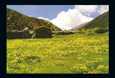
Starting
off from the Encantado's Valley, located in the National Park Los
Cardones to 3180 meters, the noticeable footpath descends 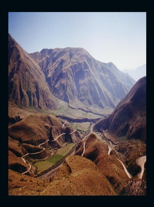 gradually
in South direction level of the 2400 meters in Escoipe's Gorge. On a
height of 2950 meters the footpath runs by a rocky gorge more and
more narrows and surrounded by farallons; this one place is known
like La Yesera. There begins to descry of way unmistakable the
magnificent Inkañan or way of the Inca.
gradually
in South direction level of the 2400 meters in Escoipe's Gorge. On a
height of 2950 meters the footpath runs by a rocky gorge more and
more narrows and surrounded by farallons; this one place is known
like La Yesera. There begins to descry of way unmistakable the
magnificent Inkañan or way of the Inca.
On the short pasturage, the russed rocks that constitute the walls of containment of the imperial's way. Internal water-drainages plugged by the time indicate the engineering importance of the work .
Is inevitable the emotion when journeying by this way located in a place whose beauty is impossible to describe. The rocky walls form innumerable eaves and bollows, where the Pre-spanish cultures made beautiful and multicolor paintings, in which they reflected aspects of their life and that today is almost impossible to decipher. Continuing the map course by the right of the stream and submerged margin between enormous vertical rocks, forrests and fields of flowers; suddenly, the panorama is opened and invades to the traveller an emptiness sensation. On the feet a cliff of about one hundred meters falls, towards both vertical flanks, thicks walls raise up one hundred meters for above, leaving a celestial strip like reference. A cascade's sound, the condor's flight and the birds's echo complete the extasis state in which submerges the lucky visitor.
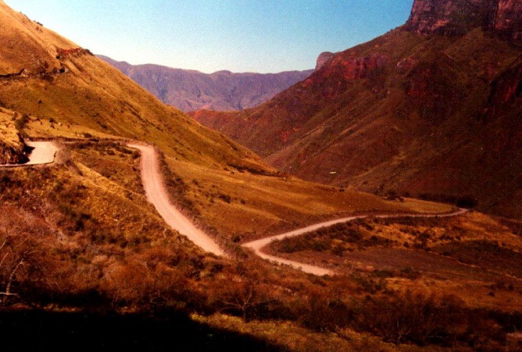
As if it was little, the way of the Inca acquires one of the more spectacular form known in the NOA. Cut like by a knife, the lofty rock of 70º of inclination yields his space to the way of the vast empire, whose main center was Cuzco. Three zig-zags are sufficient to save the one hundred meters of height. The way continues the by the low part of the gorge and again the landscape undergoes a metamorphosis, opening itself the panorama towards La Quebrada de Escoipe and La Yesera, where generous geology offers numerous foldings multicolors and to the bottom, insinuates the herbage of the Valley of Lerma. In the last section,the smoothed and zig-zag way descend 400 mts until arriving at the Maray, located on the foot of Cuesta del Obispo, in Escope's Gorge. The rediscocovery of the Inkañan in Escoipe's Gorge enriches history and geography of the region, contributing new archaeological data for the study of the Inca culture in the Argentine northwest and its impressive network of ways, motivates in addition the travellers to live a magnificent experience with a high patrimonial, historical and cultural content.
Edition: Cultural Section of El Tribuno, February 11th 2001
Photography: Javier Zap and José de Guardia de Ponté