
Inca Path in the Gorge of Las Conchas
By Christian Vitry
Translation by Vanesa Pérez Serra
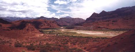
Cafayate's path through The Gorge of Las Conchas is one of the most important touristic attractions in our province. The majesty of its colourful landscape and the interesting geological and cultural history make this route a classic for travellers. Recent archaeological research carried out by UNSa researchers in The Gorge of Las Conchas proved the existance of a beautiful Inca path stretch a few metres away from the national road 68.
It is no doubt one more attraction for the delight of tourists and visitors who wish to experience closely the nature of these paths, which amazed both the Spanish conquerors and researchers and travellers of all time.
The Inca paths extend over The Andes Chain, from the southern part of Colombia till Mendoza in Argentina and Santiago in Chile, covering approximately a distance of 40.000 kilometres. Due to the great latitudinal and altitudinal development, the Inca imperial road system passed through the wildest and most varied landscapes, crossing over abysmal fords, swarms, lakes, deserts, towering peaks, steep slopes and impenetrable forests.
T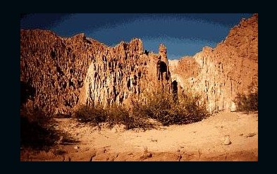 he
paths were built for a practical end, for the pedestrian transit of
human beings and llamas. These animals were used to transport
minerals and products of all kinds among the different regions of the
empire. Pre-Columbian road architecture was, is and will be admired
both by the uninformed and the scientists confronting its study. It
shows a deep knowledge of geographical space and engineering, in
perfect communion and harmony with the environment. In spite of
extending over thousands of kilometres and the variety of the
ecological floors they passed through, these archaeological paths
present construction similarities which make them distinguishable and
characteristic, like the one recently found in The Gorge of Las
Conchas. For example, if the ground was flat they traced a perfect
straight line, sometimes of several kilometres, like the Tin Tin
straight line, the present transport route in Calchaquíes
Valleys and, formerly, a pre-Columbian path. Another distinguishable
feature was joining two points or places using the shortest possible
distance and, al the same time, remembering and not obviating water
availability, the less inclined ground and other characteristics
related to geomorphology which are surprising to us nowadays.
he
paths were built for a practical end, for the pedestrian transit of
human beings and llamas. These animals were used to transport
minerals and products of all kinds among the different regions of the
empire. Pre-Columbian road architecture was, is and will be admired
both by the uninformed and the scientists confronting its study. It
shows a deep knowledge of geographical space and engineering, in
perfect communion and harmony with the environment. In spite of
extending over thousands of kilometres and the variety of the
ecological floors they passed through, these archaeological paths
present construction similarities which make them distinguishable and
characteristic, like the one recently found in The Gorge of Las
Conchas. For example, if the ground was flat they traced a perfect
straight line, sometimes of several kilometres, like the Tin Tin
straight line, the present transport route in Calchaquíes
Valleys and, formerly, a pre-Columbian path. Another distinguishable
feature was joining two points or places using the shortest possible
distance and, al the same time, remembering and not obviating water
availability, the less inclined ground and other characteristics
related to geomorphology which are surprising to us nowadays.
The different techniques applied to the construction of these paths were exceedingly adapted to the travellers and geoforms of each landscape and they aimed to reduce to the utmost physical weakening and effort. The high level of constructive sophistication was shown in constructions such as fixed bridges, wooden or rock projecting bridges, suspension bridges, floating bridges on lakes, staircases, overhead cables, ramps and huge slopes or artificial walls built over abrupt cliffs and hillsides in order to maintain the line level and the altitudinal level.
The chronicler Cieza de León remarks that " ... it was necessary to dig through slopes and bare rock to widen and flatten the path and they did that using fire and picks. In other places, there were slopes so towering and rough that they had to build steps from the bottom up to the top of them, inserting some landings to rest... all along these snow-covered places and where there were mountains full of trees and grass, they flatten the path and paved it... and where there was population, at the sides of the path, there were great palaces and accomodation for warriors and across snow-covered and countryside deserts there were lodgings where they could find shelter from the cold and the rains; and, in many places, like Collao and other parts there were signs of their leagues which they called ` tupus ' and one of these is equal to one and a half Castilian leagues ". It is worth pointing out that a Colonial League, according to some experts, measures approximately 6,3 km., that means that a tupu is equal to 9,45 km.
There
are many laudatory quotes by chroniclers, explorers and scientists
about the pre-Columbian road system. But, at this point, we should
mention 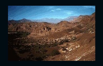 that
the paths were not exclusively Inca, since other Andean cultures like
for example the Mochicas, Tiawanacu and Wari already had paths.
However, the Inca people were the ones who improved and adapted on
what was in existance, they continued and further the constructions
where necessary and developed entirely the road system with an
astonishing geopolitical and logistic state sense, a fact that does
not cease to dazzle and amaze us. The Inca path - Qhapaq ñan o
Inka Ñan - meant much more than a way to transport products
and people throughout the different Tahuantinsuyu ecosystems, it
symbolized the power and authority of the Inca State and only their
citizens could use it. In the Toro gorge, we discovered the existance
of numerous equidistant observation posts and checkpoints scattered
along the path and visible from one another, which implies that there
was a rigourous land control. The paths were marked out by Tampus or
Tambos that were lodgings for the Inca people or for travellers in
official mission. They were also used as storehouses for food,
firewood, forrage, clothes, weapons and other necessary items for the
reign of an Inca and the state control system.
that
the paths were not exclusively Inca, since other Andean cultures like
for example the Mochicas, Tiawanacu and Wari already had paths.
However, the Inca people were the ones who improved and adapted on
what was in existance, they continued and further the constructions
where necessary and developed entirely the road system with an
astonishing geopolitical and logistic state sense, a fact that does
not cease to dazzle and amaze us. The Inca path - Qhapaq ñan o
Inka Ñan - meant much more than a way to transport products
and people throughout the different Tahuantinsuyu ecosystems, it
symbolized the power and authority of the Inca State and only their
citizens could use it. In the Toro gorge, we discovered the existance
of numerous equidistant observation posts and checkpoints scattered
along the path and visible from one another, which implies that there
was a rigourous land control. The paths were marked out by Tampus or
Tambos that were lodgings for the Inca people or for travellers in
official mission. They were also used as storehouses for food,
firewood, forrage, clothes, weapons and other necessary items for the
reign of an Inca and the state control system.
These
archaeological paths are linked together and extend over the fertile
Lerma Valley, the nearby eastern and western mountain range, the
Calchaquíes Valleys and the distant and inhospitable Puna and,
generally, travellers take no notice of them. Many mountains posses
zigzag and solid paved tracks that lead up to " sanctuaries "
placed at the high Andean peaks like the volcanoes Llullaillaco, 6739
metres high, Chañi, almost 6000 metres high, Acay, 5761 metres
high, and the Quehuar, 6130 metres high, among others.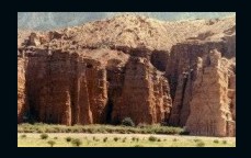 A pioneer in the research of the " Vialidad Imperial de los
Incas " ( Inca Imperial Road System, the title of one of his
works, published in 1963 ) was León Strube Erdman who with
regards to Salta province remarked " ... the continuation of the
path through Humahuaca and straight ahead appears in the plains of
Almona de Jujuy and San Antonio de Perico extending from La Caldera
to Lerma Valley and Guachipas, whose branch road to Pampa Grande was
discovered by the very Salta founder himself, " el licenciado
Lerma ". The vast Lerma Valley has three western communication
ways: through the Toro gorge, called Peru gorge till last century, an
easy stretch to La Puna; through the Escoipe gorge one leads to the
upper part of the Calchaquí valley and through Las Conchas to
the low part of the Calchaquí valley, all covered by the Inca
main mountain range path. Likewise, Spanish people mention the
existance of paths from Jujuy to Siancas or Mojoroto, leading to the
plain of Metán or Mitana, where Heredia met Keshuas Indians on
his coming back from Peru. (...) There we can find an ancient path
leading to Copolique, a station village from Rosario de La Frontera
to Antilla and Tucuman. Another old path begins at Rosario de la
Frontera from Cebilar to Candelaria and from Lampaco to Medina,
following the Tucuman plains ". According to this quote, the
path located near Lafayate would be one of the main ways that linked
the Lerma Valley with the western region.
A pioneer in the research of the " Vialidad Imperial de los
Incas " ( Inca Imperial Road System, the title of one of his
works, published in 1963 ) was León Strube Erdman who with
regards to Salta province remarked " ... the continuation of the
path through Humahuaca and straight ahead appears in the plains of
Almona de Jujuy and San Antonio de Perico extending from La Caldera
to Lerma Valley and Guachipas, whose branch road to Pampa Grande was
discovered by the very Salta founder himself, " el licenciado
Lerma ". The vast Lerma Valley has three western communication
ways: through the Toro gorge, called Peru gorge till last century, an
easy stretch to La Puna; through the Escoipe gorge one leads to the
upper part of the Calchaquí valley and through Las Conchas to
the low part of the Calchaquí valley, all covered by the Inca
main mountain range path. Likewise, Spanish people mention the
existance of paths from Jujuy to Siancas or Mojoroto, leading to the
plain of Metán or Mitana, where Heredia met Keshuas Indians on
his coming back from Peru. (...) There we can find an ancient path
leading to Copolique, a station village from Rosario de La Frontera
to Antilla and Tucuman. Another old path begins at Rosario de la
Frontera from Cebilar to Candelaria and from Lampaco to Medina,
following the Tucuman plains ". According to this quote, the
path located near Lafayate would be one of the main ways that linked
the Lerma Valley with the western region.
The
Inca path stretch identified in The Gorge of Las Conchas can be found
in the spot known as " Las Ventanas ", and can be easily
spotted from the car a few metres away from the road. It is a 50
metres 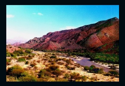 long
ramp over a lateral slope which comes up to a 60 metres high uneven
ground. It has supporting walls over one metre high and it is built
with selected granitic rocks, which gives it solidity and beauty. In
spite of the passing of centuries and the erosive processes, the
walls that support the path are still erect.
long
ramp over a lateral slope which comes up to a 60 metres high uneven
ground. It has supporting walls over one metre high and it is built
with selected granitic rocks, which gives it solidity and beauty. In
spite of the passing of centuries and the erosive processes, the
walls that support the path are still erect.
Heritage and Tourism
The present article highlights an Inca path stretch for the enjoyment of society as a whole and tourists. These archaeological remains are full of sense and history which belongs to all of us. The only way to uncover the mysteries they treasure is through research and cultural resources management, both aiming at the appraisal, conservation and preservation of this cultural heritage, as well as an adequate treatment of the information that it offers to visitors.
We have in our hands a priceless legacy from our ancestors and it is our duty to protect it so that future generations can also enjoy it and produce scientific research with the technology of their times. In the near future, province authorities are likely to signpost the place as " Camino del Inca " ( Inca Path ), but this is not enough if the steps mentioned before are not taken. There are numerous distinguishable Inca path stretches in Salta, their systematic study is bringing to light new data for the archaelogical records, a fact that suggests a revision of the whole of the Andean ambit. Recognizing them allows us an approach to the Inca culture and, at the same time, a reading of the landscapes of the past full of meanings, an approach that could acquire a social, educative, cultural and touristic relevance.
Edition: Cultural Section of El Tribuno, January 7th 2001
.